Description
Two single-storey, red sandstone buildings dated 1895 and constructed as part of a water filtering station by the civil engineers J & A Leslie & Reid, Edinburgh. Rectangular on plan with snecked, rock-faced walls, ashlar dressings and neo-Baroque style details. Pitched slate roofs with crowstepped gables and moulded skewputts. The interior of the north building contains a sunken water tank, with its associated equipment retained. The buildings and the wider site are vacant and no longer in use as the operational water works is now to the north. The site is located in a rural setting to the northwest of the village of Glassford. The buildings are situated on elevated ground, to the north and south of the former filter beds.
Main (east) elevations are gabled with a single central bay. Twin-leaf timber-panelled entrance door with a swan-neck pedimented doorpiece and a louvered oculus above. Lintel to north building has 'LMWDWW 1895' in carved stone. Side (north and south) elevations are three bays divided by ashlar piers, with two window openings and blind slits. Rear elevation of south building has a two-bay red brick extension to west, with a flat roof and parapet (dating from earlier-to-mid 20th century and excluded from the listing).
Steeply pitched, graded slate roofs with terracotta ridge tiles. Cast iron rainwater goods on moulded eaves courses. Windows are 12-light timber casements, bi-partites to the north building, all boarded over with one having collapsed internally.
The interiors were seen in 2023 and contain single open spaces with ashlar red sandstone walls, diagonal timber panelling to the roofs, braced with open metal trusses. The south building has a concrete floor. The north building has a sunken water tank lined with glazed bricks and an inspection walkway around perimeter with guard rails and gangway to east. Associated metal pipework, ladders and the sluice and spill mechanisms all remain. A large stone archway to the west end leads into the adjacent covered reservoir (no longer in use and not part of the listing).
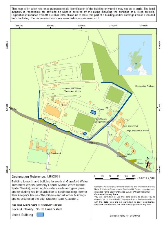
The site is bound by dressed rubble walls with rounded copings and ashlar gate piers with caps stones (one removed but retained behind gate pier) and later metal gates. There is a set of stone steps with a coped dwarf wall to the east of the north building and the south of the south building. The site contains a number of other buildings associated with the water works, including the former filter keeper's cottage - these are all excluded from the listing.
The filter beds between the two buildings appear to have been filled in and truncated to the west. It is unclear what remains of the covered reservoir to the west of the north building but its overall form remains evident in the landscape. (Also see Section 6. Legal exclusions)
Historical development
Dated 1895, the buildings are first shown on the 2nd Edition Ordnance Survey map (revised 1896, published 1897) along with the associated filter beds, covered reservoir and filter keeper's house. They were built as part of the Lanarkshire Middle Ward District Water Works (later Glassford Water Treatment Works), which was established after the district suffered "…something approaching a 'water famine'…" in the summer of 1890 (Glasgow Herald, 23 November 1892, p. 4).
An Act of Parliament, 'The Lanarkshire (Middle Ward District) Water Act 1892' was obtained to enable the District Committee to construct waterworks to supply the area with water. Led by the Edinburgh-based civil engineering firm of J & A Leslie and Reid, the scheme saw the construction of two new reservoirs on Glengavel Water, a tributary of the Avon and the Clyde, along with a number of service reservoirs and a considerable length of piping. The reservoir at High Plewlands was built first and the water fed by gravity to the high ground at Glassford, where it was filtered through the sand and then distributed via a series of pipes through the district. The estimated cost of the scheme was over £200,000. (Glasgow Herald, 23 November 1892, p.4) and the first gravitation water reached Strathaven in 1896 (Downie, 1979). A second reservoir (at Kype) opened in 1898.
The two buildings at Glassford were part of the scheme's principal filter station and were constructed between 1894 and 1896 (Hamilton Herald and Lanarkshire Weekly News, 24 August 1907, p. 5). Henderson and Duncan, of Edinburgh were responsible for the construction of the four filter beds and clear water tanks at Glassford (Edinburgh Evening News, 7 April 1894), but it is likely that J & A Leslie and Reid were responsible for the design.
The site was selected for its high elevation (760 ft above Ordnance Survey datum), which meant that the system could be largely gravitational, rather than relying on a need for pumping (Tait, 1903: p. 335). Additional sand filter beds were constructed at Glassford around 1907 (The Scotsman, 17 November 1906) and in the early 1930s a large reservoir was completed at Camps near Crawford, which was partially used to increase the supply from Glengavel reservoir.
The two buildings appear to have remained largely unchanged since their construction, with the exception of the red brick extension to the west of the south building. This was added in the first half of the 20th century, but its original purpose is not known.
Further filter beds and a reservoir were added to the north of the site, along with some small-scale structures to the north, south and east by the early 1960s (National Grid map, surveyed 1961, published 1963). These later filter beds and reservoir have now been filled in and planted. The filter beds were truncated around the later 20th century when a large water treatment building was constructed, along with a number of associated structures, which are largely concentrated to the west side of the site. These buildings are now vacant and a large covered reservoir is situated to the north.
The former filter keeper's house is in private ownership and has been extended and altered in recent decades.
Statement of Special Interest
The two buildings at Glassford Water Works meet the criteria of special architectural or historic interest for the following reasons:
- Designed in a neoclassical style typical for their date and type, they are good representative examples of buildings associated with the provision of clean water in the late-19th century.
- They survive largely in their original form and retain many of their 19th century features associated with their function as a water works.
- The wider setting has been partially altered but a number of ancillary features are retained, contributing our understanding of how the site would have originally operated.
- They form part of a group of historic structures that are of social historical interest for what they can tell us about the supply of clean water to the district in the late-19th century and the municipal ambition of the period.
In accordance with Section 1 (4A) of the Planning (Listed Buildings and Conservation Areas) (Scotland) Act 1997 the following are excluded from the listing: red brick addition to south building, former Filter Keeper's House (The Filters) and all other buildings at the site.
Architectural interest
Design
Although functional in nature, structures relating to the supply of potable water were a public expression of civic pride and were often afforded fine architectural treatment, with some designed as focal points in the landscape. (Barnton, 2003: p.32)
Designed in an eclectic neoclassical style, the two water works buildings at Glassford are typical examples for their date and type. They display good-quality architectural detailing that combines elements of neo-classicism with some traditional Scottish architectural features, such as the crowstepped gables. Their design quality reflects the civic achievement of bringing a supply of clean water to this large and scattered district.
The plan form and interior of both buildings appear to have remained largely unchanged, with the exception of the red brick addition to the south building. The interiors are simple, reflecting the functional nature of their original use but their finish reflects the quality that was afforded to municipal schemes during this period.
The retention of the original features in the north building, such as the water tank, inspection walkway and sluice mechanism, are of particular note for what they can tell us about how the water works would have originally functioned.
The civil engineering firm of J & A Leslie and Reid were responsible for many major reservoir schemes across Scotland during the 19th and early 20th centuries, including Alnwickhill, Rosebury, Gladhouse and Edgelaw. The buildings at Glassford show some similarity to J & A Leslie's earlier designs for outlet houses at Alnwickhill Reservoir in Edinburgh, built in the 1870s and 1880s (listed category B, ref: LB43246). However, these are more strictly neo-classical in their detailing, as opposed to the more loose, neo-Baroque style evident at Glassford. Similar examples of waterworks' buildings by the firm also survive nearby in Edinburgh, at Fairmilehead (listed category B, ref: LB45834) and at Firr Hill (not listed), both of which date to around 1910.
The buildings at Glassford Water Works are of a typical design for their late-19th century date, they survive largely unaltered, and their design quality reflects the municipal self-confidence of the period. On balance they are representative examples of structures associated with the large-scale provision of clean water in late-19th century Scotland, which retain much of their original character and form.
Setting
The buildings at Glassford Water Works are located in a remote rural setting, approximately 2.5 miles north of Strathaven and 1 mile northwest of the village of Glassford. The pair are prominently sited next to a road, on artificially raised ground that formed part of the original filter beds. The setting of the original water works is of special interest in relation to its function. The site was specifically selected for its high elevation and position in relation to Glengavel Water, which enabled the scheme to be gravity based, rather than relying on pumping mechanisms.
The immediate setting has remained relatively unchanged except for the filter beds. These were originally open and were first expanded to the west in the early 20th century and have since been filled in. They have been planted with tall conifers, meaning that the two buildings are no longer intervisible. A number of original ancillary features remain, including much of the boundary walls and gate piers, two sets of ashlar stone steps, the former filter beds and covered reservoir (although the extent of survival is unclear), and the former filter keeper's cottage.
The wider setting within the site itself has been partially altered by the development of the site from the mid-20th century onwards, which saw the construction of a number of different water-related buildings and structures. The surrounding area has remained fairly unaltered, the most significant change being the loss of the nearby railway and station building that ran to the northwest of the site.
On balance the overall impact of these changes is minimal. Much of the character of the historic setting remains evident and the retention of the ancillary features contributes to our understanding of how the site would have functioned.
Historic interest
Age and rarity
The older a building is, and the fewer of its type that survive, the more likely it is to be of special interest. Structures relating to the supply of clean water can be found across Scotland and, as such, they are not rare building types. Those that are early in date or are notable examples of their type may be of interest for listing.
The need to provide clean drinking water to every household became particularly important after the discovery that cholera was linked to the drinking of impure water in the mid-19th century. The damming of an upland river or stream, combined with filtration, enabled a constant and reliable supply of clean, safe water to be available throughout the year. The supply of filtered water was generally focused on the major towns and cities and to the growing industrial areas, and gravity fed systems became standard in Scotland due to the abundance of upland catchments near to urban areas (Hume, 2005: p. 343).
Early examples of large-scale water supply schemes that survive in Scotland include Glencorse Reservoir (1820-24); Perth Water Works (1832, listed category A ref: LB39341), Torduff Reservoir (1848, listed category C, ref: LB50528) and Loch Katrine (1859, listed category A ref: LB50298).
The Franchise Reforms and Public Health Acts in the 1860s enabled local authorities to take water organisations and systems into public ownership. The Act of 1889 transferred all public health duties, including water, to the District Committees of the County Council, enabling larger county-wide schemes to be built. This was aided by a rise in the production of cast iron pipes in the later 19th century, which allowed water to be piped over long distances, resulting in a rise of supply to smaller towns and villages (Barton, 2003: p.46). By the late-19th century district water schemes had spread rapidly but more rural areas still relied on private wells, springs and cisterns for their water supplies.
The buildings at Glassford Water Works cannot be considered early or innovative examples for their date and type. They are however important components of a large-scale water supply scheme of the late-19th century, which sought to bring clean water to an area that was cited as being more than double the area of the County of London (Tait, 1903: p. 329). As such, they are significant representative examples of their building type at the end of the 19th century. The buildings at Glassford survive relatively unaltered, and along with the associated Glengavel Reservoir and ancillaries, they form part of a historically related group of structures associated with the supply of clean water to more rural areas.
Social historical interest
Social historical interest is the way a building contributes to our understanding of how people lived in the past, and how our social and economic history is shown in a building and/or in its setting.
Water supply schemes are a key part of Scotland's rural and urban landscape, and they are important for what they can tell us about the social and economic development of an area.
Glassford was part of a significant municipal scheme that supplied clean and safe water to an unusually large district, where the population was very scattered and at widely different levels. The buildings at Glassford are representative of the ambitions and achievements of Victorian civil engineering. They are also a tangible reminder of the impact that a clean water supply had to the health and well-being of the area, as well as its economic development.
References
Bibliography
Maps
Ordnance Survey (revised 1896, published 1897) Lanarkshire XXIII.8. 25 inches to the miles. 2nd and later editions. Southampton: Ordnance Survey.
Ordnance Survey (revised 1910, published 1912) Lanarkshire XXIII.8. 25 inches to the miles. 2nd and later editions. Southampton: Ordnance Survey.
Ordnance Survey (revised 1961, published 1963) NS7047-NS7147 – AA. 1:2500. National Grid Maps. Southampton: Ordnance Survey.
Archives
Glasgow Herald, 23 November 1892, p.4.
Glasgow Herald, 9 May 1893, p.1.
Edinburgh Evening News, 7 April 1894, p. 3.
The Scotsman, 17 November 1906, p. 1.
Hamilton Herald and Lanarkshire Weekly News, 24 August 1907, p. 5.
Hamilton Advertiser, 31 December 1910, p. 5.
Printed Sources
Barton, B. (2003) Water Towers of Britain. Newcomen Society. pp. 3, 12, 25-27, 32-33, 46-47.
Hume, J. Chapter 17, Public Services in Stell, G., Shaw, J. and Storrier, S. (2005) Scottish Life and Society, Scotland's Buildings – A Compendium of Scottish Ethnology, Vo. 3. Tuckwell Press Ltd. pp. 341-345.
Online Sources
Trove Montrose Water Works, accessed at https://www.trove.scot/place/121930/
Dictionary Scottish Architects, J & A Leslie and Reid, accessed at https://www.scottisharchitects.org.uk/architect_full.php?id=205287
Extracts from: Downie, William Fleming (1979) A History of Strathaven and Avondale, accessed at https://upperavonangling.co.uk/the-history-of-glengavel-reservoir-water-supply-in-starthaven
Tait, W. A. P. (1903) New Lanarkshire Middle-Ward District Waterworks, pp. 329-341. accessed at https://zenodo.org/records/1777139
Sales particulars, accessed at https://www.avisonyoung.co.uk/properties/-/property/detail-112392
The History of Water, Scottish Water, accessed at https://www.scottishwater.co.uk/-/media/ScottishWater/Document-Hub/Careers-and-Education/Education-Modules/Second/250718TheHistoryofWater.pdf
About Listed Buildings
Historic Environment Scotland is responsible for designating sites and places at the national level. These designations are Scheduled monuments, Listed buildings, Inventory of gardens and designed landscapes and Inventory of historic battlefields.
We make recommendations to the Scottish Government about historic marine protected areas, and the Scottish Ministers decide whether to designate.
Listing is the process that identifies, designates and provides statutory protection for buildings of special architectural or historic interest as set out in the Planning (Listed Buildings and Conservation Areas) (Scotland) Act 1997.
We list buildings which are found to be of special architectural or historic interest using the selection guidance published in Designation Policy and Selection Guidance (2019)
Listed building records provide an indication of the special architectural or historic interest of the listed building which has been identified by its statutory address. The description and additional information provided are supplementary and have no legal weight.
These records are not definitive historical accounts or a complete description of the building(s). If part of a building is not described it does not mean it is not listed. The format of the listed building record has changed over time. Earlier records may be brief and some information will not have been recorded.
The legal part of the listing is the address/name of site which is known as the statutory address. Other than the name or address of a listed building, further details are provided for information purposes only. Historic Environment Scotland does not accept any liability for any loss or damage suffered as a consequence of inaccuracies in the information provided. Addresses and building names may have changed since the date of listing. Even if a number or name is missing from a listing address it will still be listed. Listing covers both the exterior and the interior and any object or structure fixed to the building. Listing also applies to buildings or structures not physically attached but which are part of the curtilage (or land) of the listed building as long as they were erected before 1 July 1948.
While Historic Environment Scotland is responsible for designating listed buildings, the planning authority is responsible for determining what is covered by the listing, including what is listed through curtilage. However, for listed buildings designated or for listings amended from 1 October 2015, legal exclusions to the listing may apply.
If part of a building is not listed, it will say that it is excluded in the statutory address and in the statement of special interest in the listed building record. The statement will use the word 'excluding' and quote the relevant section of the 1997 Act. Some earlier listed building records may use the word 'excluding', but if the Act is not quoted, the record has not been revised to reflect subsequent legislation.
Listed building consent is required for changes to a listed building which affect its character as a building of special architectural or historic interest. The relevant planning authority is the point of contact for applications for listed building consent.
Find out more about listing and our other designations at www.historicenvironment.scot/advice-and-support. You can contact us on 0131 668 8914 or at designations@hes.scot.
Map
Printed: 28/07/2026 00:31